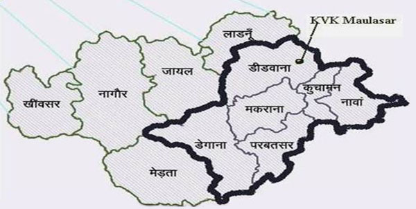
District Profile
Nagaur district is situated in Western part of Rajasthan between 260 25’ to 27040’ North latitude and 730 18’ to 750 15’ East longitude. Nagaur district falls under agro climatic zone II-A called as transitional plans of inland drainage. It covers an area of 17778 sq. km. out of which 17448.5 sq. km is rural area and 269.5 sq. km is urban. The Nagaur district is bounded on the north by Bikaner and Churu districts, on the east by Sikar and Jaipur districts, on the south by Ajmer, and Pali districts and on the west by Jodhpur districts. There are 13 tehsil headquarters in the district viz. Nagaur, Khinwsar, Jayal, Degana, Didwana, Ladnun, Parbatsar, Makarana, Nawa, Kuchaman, Riyanbadi and Mundwa. The district is divided into 14 blocks (Panchayat Samitis) viz. Nagaur, Khinvsar, Mundwa, Jayal, Merta, Riyan, Degana, Didwana, Molasar, Ladnun, Parbatsar, Makarana, Nawa and Kuchaman. Out of which 7 Panchayat samitis Didwanan, Degana, Molasar, Parbatsar, Makarana, Nawa and Kuchaman are under jurisdiction of this KVK i,e; Nagour II.

Agro Ecology, Climate, Hydrology and Topography of Nagaur
| S.N. | Agro Ecological Zone Type | Type of Terrain | District Area(000’ha) | Normal Annual Rainfall (mm) | Avg. Monthly Rainfall (mm) | No. of Rainy Days | Maximum Rainfall Intensity (mm) |
|---|---|---|---|---|---|---|---|
| 1 | Western Plain, Kachchh and part of Kathiawar Peninsula, Hot and Eco Region | Elevationof plains varies from 300 m (amsl*) in north to 150 m (amsl) in south | 2256.4 | 263 | 22 | 27 | Up to 15 min : 63 Beyond 15 but upto 30 min : 52 Beyond 30 but upto 60 min : 48 |
Infrastructure / Facilities Available
| Infrastructure | Status |
|---|---|
| Administrative Building | Completed |
| Staff Quarters | No |
| Farmer Hostel | Completed |
| Demonstration Units | Completed |
| Any Other | Seed Godawan (MIDH) |
Vehicle Facilities
| Vehicle | Yes / No |
|---|---|
| Jeep | Yes |
Farm Machinery
| Farm Machinery | Status |
|---|---|
| Tractor | 1 |
| Harrow | 1 |
| Disk Harrow | 1 |
| Cultivator | 1 |
| Leveller | 1 |

